Esplanade Drainage Works
Frankston City Council has completed the installation of a large diameter stormwater drainage pipe within the roadway of the Esplanade between High Street and Williams Street, Frankston.
Why is the project needed?
In urban environments stormwater is conveyed from properties and roads through a series of underground pipes and pits before it reaches an open watercourse such as a stream and eventually a coastal waterbody.
Pipelines are located within roadways, reserves, or in easements when travelling through private properties.
Responsibility management of these piped networks is typically vested with Councils for smaller pipelines, and Melbourne Water for larger pipelines.
Areas that collects stormwater flows are called catchments and are determined by the lay of the land and resultant flow of water.
Frankston City Council undertakes investigations and modelling of the catchments it manages in order to identify areas of potential flooding and to prioritise drainage improvement works at these locations.
These works form part of the implementation of the Frankston South Drainage Strategy, a series of priorities works based on investigation and modelling to improve network capacity and reduce flood risk in the area.
The strategy area is bound by Frankston Flinders Road (East), Port Phillip Bay (West), Hastings Road (North), and the top of the catchment towards Humphries Road (South).
The Esplanade pipeline is in the Warringa and Williams Catchments of Frankston South. Further stages that will connect to this pipeline include works on Cliff Road, Bay Street South, Helen Street and Gweno Avenue.
These works will improve network capacity in the areas of High Street, the Esplanade, Nolan Street, Williams Street, Cliff Road, and Warringa Road, as well as nearby streets.
Scope of Works
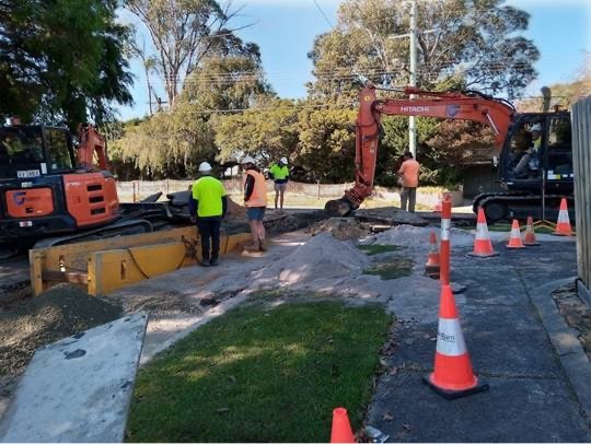
Works will include deep excavation, pipe laying, installation of pits, and backfilling and reinstatement of the roadway.

Please note: This is an example image of similar scale stormwater drainage installation.
Project Timeline
Works commenced on Monday 17th January 2022 with an estimated duration of approximately 2 months.
How will the works impact Residents and Road Users?
Progressive road closures will be in place as follows:
- High Street and the Esplanade, from east of Bay Street South to north of Nolan Street. Access to Nepean Hwy via the Folly (service road) will be closed.
- The Esplanade from north of Nolan Street to south of Williams Street. Nolan-Esplanade intersection closed.
- The Esplanade and Cliff Road approximately 50m either side of Williams Street. Williams-Cliff/Esplanade intersection closed.
Due to the nature of works and deep excavations the closure of these locations to through traffic is the safest and most efficient approach to completing these works for workers and the community.
Residents in proximity to work zones are requested to please remove any vehicles parked on the roadway by 7am each morning and ensure the roadway remains clear until the works are completed.
Access to properties within the road closure will remain at all times where possible. If access cannot be retained onsite staff will give advanced notification and liaise with impacted properties to accommodate requirements.
Concrete pits and pipes will be stored on nature strips for short periods before being installed, and some noise and minor vibration will be emitted by construction equipment and associated activities.
We apologise for any inconvenience that this may cause. Council appreciates your cooperation and patience during the delivery of these works.
For any construction site related questions or concerns please contact Jaydo Construction at info@jaydo.com.au For any general questions or concerns related to the Frankston South Drainage Strategy Implementation please contact Council’s Project Manager on 1300 322 322 or email CapWorks@frankston.vic.gov.au.